Change Detection for Urban Area (Al Diwaniyah city) and Flat Water (Al Dalmaj marsh) using Multi-Temporal and Static Methods
DOI:
https://doi.org/10.71229/2qsmg829Keywords:
Change detection,, Satellite imagery,, Multi-temporal analysis,, Urban areas, , Wetland ecosystemsAbstract
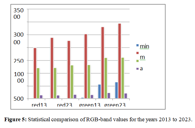
Change detection is considered one of the most important applications in digital image processing, especially for satellite images. In this study, a tripartite strategy was employed to analyse changes in two distinct regions; the city of Diwaniyah in central Iraq and the Al-Dalmaj marsh located from east of the city. The first method utilised multi-temporal image subtraction to identify timing variations among datasets. The second technique depended on statistical analysis, involving estimating standard deviation and other crucial parameters for assessing spectrum and geographically fluctuations. The third aspect was geometric appraisal, particularly required determining the area and perimeter of the target regions to evaluate changes in their spatial attributes over time
References
1. Seto, K.C., et al., A meta-analysis of global urban land expansion. PloS one, 2011. 6(8): p. e23777.
2. Grimm, N.B., et al., Global change and the ecology of cities. science, 2008. 319(5864): p. 756-760.
3. Wulder, M.A., et al., Land cover 2.0. International Journal of Remote Sensing, 2018. 39(12): p. 4254-4284.
4. Hansen, M.C., et al., High-resolution global maps of 21st-century forest cover change. science, 2013. 342(6160): p. 850-853.
5. Pekel, J.-F., et al., High-resolution mapping of global surface water and its long-term changes.
6.
7. Nature, 2016. 540(7633): p. 418-422.
8. Moreira, A., et al., A tutorial on synthetic aperture radar. IEEE Geoscience and remote sensing magazine, 2013. 1(1): p. 6-43.
9. Drusch, M., et al., Sentinel-2: ESA's optical high-resolution mission for GMES operational services. Remote sensing of Environment, 2012. 120: p. 25-36.
10. Tapete, D. and F. Cigna, SAR for landscape archaeology. Sensing the Past: From artifact to historical site, 2017: p. 101-116.
11. Zhu, Z., S. Wang, and C.E. Woodcock, Improvement and expansion of the Fmask algorithm: Cloud, cloud shadow, and snow detection for Landsats 4–7, 8, and Sentinel 2 images. Remote sensing of Environment, 2015. 159: p. 269-277.
12. Schowengerdt, R.A., Remote sensing: models and methods for image processing. 2006: elsevier.
13. Ustin, S.L. and S. Jacquemoud, How the optical properties of leaves modify the absorption and scattering of energy and enhance leaf functionality. Remote sensing of plant biodiversity, 2020:
14. p. 349-384.
15. Im, J. and J.R. Jensen, Hyperspectral remote sensing of vegetation. Geography Compass, 2008.
16. 2(6): p. 1943-1961.
17. Gu, Z. and M. Zeng, The use of artificial intelligence and satellite remote sensing in land cover change detection: Review and perspectives. Sustainability, 2024. 16(1): p. 274.
18. Zhang, J., Multi-source remote sensing data fusion: status and trends. International journal of image and data fusion, 2010. 1(1): p. 5-24.
19. Cheng, G., et al., Change detection methods for remote sensing in the last decade: A comprehensive review. Remote Sensing, 2024. 16(13): p. 2355.
20. Mountrakis, G., J. Im, and C. Ogole, Support vector machines in remote sensing: A review. ISPRS journal of photogrammetry and remote sensing, 2011. 66(3): p. 247-259.
21. Szostak, M., M. Pietrzykowski, and J. Likus-Cieślik, Reclaimed area land cover mapping using Sentinel-2 Imagery and LiDAR Point Clouds. Remote Sensing, 2020. 12(2): p. 261.
22. Jiang, J., J. Liu, and D. Jiao, Aerosol optical depth retrieval for sentinel-2 based on convolutional neural network method. Atmosphere, 2023. 14(9): p. 1400.
23. Roy, D.P., et al., Landsat-8: Science and product vision for terrestrial global change research.
24. Remote sensing of Environment, 2014. 145: p. 154-172.
25. Jianya, G., et al., A review of multi-temporal remote sensing data change detection algorithms. The International Archives of the Photogrammetry, Remote Sensing and Spatial Information Sciences, 2008. 37(B7): p. 757-762.
26. Zhu, X.X., et al., Deep learning in remote sensing: A comprehensive review and list of resources.
27. IEEE geoscience and remote sensing magazine, 2017. 5(4): p. 8-36.
28. Wang, Q., et al., GETNET: A general end-to-end 2-D CNN framework for hyperspectral image change detection. IEEE Transactions on Geoscience and Remote Sensing, 2018. 57(1): p. 3-13.
29. Shobeiri, S., Digital change detection using remotely sensed data for monitoring green space destruction in Tabriz. 2007.
30. Lu, D., et al., Change detection techniques. International journal of remote sensing, 2004. 25(12):
31. p. 2365-2401.
32. Zhang, C., et al., An object-based convolutional neural network (OCNN) for urban land use classification. Remote sensing of environment, 2018. 216: p. 57-70.
33. Al-Dabbas, M.A., W.M. Jassim, and W.H. Kadhim, Hydrochemical Evaluation Of The Main Drain And Hor Dalmaj, Central Iraq. The Iraqi Geological Journal, 2016: p. 36-48.
34. Cotruvo, J.A., 2017 WHO guidelines for drinking water quality: first addendum to the fourth edition. Journal-American Water Works Association, 2017. 109(7): p. 44-51.
35. Hassan, Z.D. and S.F. Hassan, Using Remote Sensing Techniques and Geographic Information Systems in Changes Detection of Marsh Al Dalmaj Period 2000-2017 and Its Impact on Some Engineering Properties. Iraqi Journal of Science, 2024: p. 3212-3223.
36. Peng, D., Y. Zhang, and H. Guan, End-to-end change detection for high resolution satellite images using improved UNet++. Remote Sensing, 2019. 11(11): p. 1382.
37. Chen, H. and Z. Shi, A spatial-temporal attention-based method and a new dataset for remote sensing image change detection. Remote sensing, 2020. 12(10): p. 1662.
38. Jiang, H., et al., A survey on deep learning-based change detection from high-resolution remote sensing images. Remote Sensing, 2022. 14(7): p. 1552.
39. Al-Mashhadani, M.M.N. and H.K. Jasim, Mineralogy of Sand Dune Fields around Hor Al-Dalmaj Between Wasit and Al-Qadesiyah Governorates-Central Iraq. Iraqi Journal of Science, 2022: p. 3478-3488.
40. Chen, Z.R., et al., Impact of water resources utilization on the hydrology of Mesopotamian marshlands. Journal of Hydrologic Engineering, 2011. 16(12): p. 1083-1092.
41. Saud, S.S., S.A. Abdullah, and B.M. Hashim, Assessment of Sustainable Urban Expansion with Land Use and Land Cover Changes for Al-Hillah City Using Remote Sensing and GIS Techniques. Iraqi Journal of Physics, 2023. 21(4): p. 66-76
Downloads
Published
Issue
Section
License
Copyright (c) 2026 Al-Noor Journal of Engineering Management and Computer Science

This work is licensed under a Creative Commons Attribution-NonCommercial-ShareAlike 4.0 International License.
How to Cite