Spatial Modeling of Soil Behavior the Integration of Geographical System and Advanced Mathematical Analysis
DOI:
https://doi.org/10.71229/4v311a92Keywords:
Advanced Mathematical Analysis, Geographic Information Systems, Geostatistical Characterization, Spatial Modeling, Artificial Neural NetworksAbstract
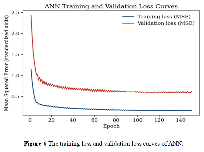
The land is covered with soil, except somewhere of the ice or bare rock, and its present varies in their continuously. Accurate determination of soil properties plays a vital role in the safe and inexpensive construction of various structures. This work presented an integrated Geostatistic-Artificial Neural Network (ANN) approach to characterise and predict the behaviour of the soil as a proof of concept target variable, taking electrical conductivity (EC) in a virtual landscape containing four classes of soil (N = 100) as the target variable. The four hypothetical soil classes were: (Saline-Gypsiferous, Silty Clay Loam Alluvial, Sandy Loam and Calcareous) simulated in a spatially 100 x 100 grid domain, with using physicochemical parameters taken from literature. The spatial dependency of EC was tested using experimental semivariogram analysis and Moran's' I, and an interpolated salinity surface was created using a distance-weighted estimator; EC spatial data coordinates and eight physicochemical data descriptors were used for training a Multi-Layer Perceptron with two hidden layers (16 and 8 neurons respectively). The geostatistical analysis showed high spatial structure with a very low nugget to sill ratio (6.4%), a high positive Moran's I value (0.278), and a range of 169.82 grid units which gave a smooth looking, physically sound interpolated surface that correctly identified and plotted the high salinity zone. The overall predictability of the ANN was high (R-squared = 0.68) but low (R-squared = 0.214) for the held-out test set with class-stratified analysis indicating that the only significant contribution to predictability came from the ability of the ANN to separate soil classes rather than from the ability to express within-soil class variance. This reflects that the limited sample size compared to the complexity of this part of the ANN was a major limiting constraint on the generalizations. These results suggest that geostatistical and machine-learning techniques are complementary and not mutually exclusive: variogram-based techniques provide valuable and powerful, “data-efficient” spatial description, but ANNs have the potential to include multivariate covariates if sufficient training data are present. The extension of this pipeline to larger sizes or field measured datasets, complete kriging and hybrid regression-kriging implementations is recommended for future research to enable operational soil salinity mapping in real arid-semi-arid alluvial environments.
References
[1] Rash, A.J.H., Khodakarami, L., Muhedin, D.A., Hamakareem, M.I. and Ali, H.F.H., 2024. Spatial modeling of geotechnical soil parameters: Integrating ground-based data, RS technique, spatial statistics and GWR model. Journal of Engineering Research, 12(1), pp.75-85. DOI: https://doi.org/10.1016/j.jer.2023.10.026
[2] Heuvelink, G.B.M. and Webster, R., 2001. Modelling soil variation: past, present, and future. Geoderma, 100(3-4), pp.269-301. DOI: https://doi.org/10.1016/S0016-7061(01)00025-8
[3] Kazmi, Z. and Sodangi, M. (2021). Integrated Analysis of the Geotechnical Factors Impeding Sustainable Building Construction—The Case of the Eastern Province of Saudi Arabia. Sustainability. doi: 10.3390/su13126531. DOI: https://doi.org/10.3390/su13126531
[4] Kousar, R., Lone, A. H., Shah, Z. A., Dar, E., Mir, M. S., Alkeridis, L. A., Al‐Shuraym, L., Ganie, M. A., Bhat, J. A., Alshehri, M. A., Sayed, S., Shukry, M., Wani, O. A., Jehangir, I. A., Wani, F. J., Baba, Z. A., Sofi, N., Mubarak, T., Hussain, A. and Summuna, B. (2025). Farm-scale soil spatial variability at a mountain research centre in Northwestern Himalayas. Scientific Reports, 15. DOI: https://doi.org/10.1038/s41598-025-03695-0
[5] Szatmári, G. and Pásztor, L. (2019). Comparison of various uncertainty modelling approaches based on geostatistics and machine learning algorithms. Geoderma. DOI: https://doi.org/10.1016/j.geoderma.2018.09.008
[6] Helfenstein, A., Mulder, V. L., Broeke, M. H.-T. J. D., Van Doorn, M., Teuling, K., Walvoort, D. and Heuvelink, G. (2024). BIS-4D: mapping soil properties and their uncertainties at 25 m resolution in the Netherlands. Earth System Science Data. doi: 10.5194/essd-16-2941-2024. DOI: https://doi.org/10.5194/essd-2024-26
[7] Cabot, M. L., H. and Eijnden, A. V. D. (2012). Investigation of the reduction in uncertainty due to soil variability when conditioning a random field using Kriging. Geotechnique Letters, 2, pp. 123-127. doi: 10.1680/geolett.12.00022. DOI: https://doi.org/10.1680/geolett.12.00022
[8] Micić, K., Bui, H.G. and Ninić, J., 2025. Computer-aided ground modelling incorporating soil variability for geotechnical applications. In Proceedings of the Southeastern Europe Tunnelling Conference (SETC-2025), 1-3 October 2025, Belgrade, Serbia (pp. 283-293). Srpsko udruženje za tunele i podzemne objekte (ITA Srbija). DOI: https://doi.org/10.5937/SETC25026M
[9] Alibekova, N., Aniskin, A., Mukhambetkaliev, K. and Makasheva, I. (2026). A review of the current state of 3D subsurface cartography for geotechnical ground characterization. Technobius. DOI: https://doi.org/10.54355/tbus/6.1.2026.0097
[10] Schmidinger, J. and Heuvelink, G.B., 2023. Validation of uncertainty predictions in digital soil mapping. Geoderma, 437, p.116585. DOI: https://doi.org/10.1016/j.geoderma.2023.116585
[11] Wadoux, A.M.C., Minasny, B. and McBratney, A.B., 2020. Machine learning for digital soil mapping: Applications, challenges and suggested solutions. Earth-Science Reviews, 210, p.103359. DOI: https://doi.org/10.1016/j.earscirev.2020.103359
[12] Pereira, G. W., Valente, D., Queiroz, D. M., Coelho, A. L. F., Costa, M. and Grift, T. (2022). Smart-Map: An Open-Source QGIS Plugin for Digital Mapping Using Machine Learning Techniques and Ordinary Kriging. Agronomy. DOI: https://doi.org/10.3390/agronomy12061350
[13] Zhu, C., Wei, Y., Zhu, F., Lu, W.-J., Fang, Z., Li, Z. and Pan, J. (2022). Digital Mapping of Soil Organic Carbon Based on Machine Learning and Regression Kriging. Sensors (Basel, Switzerland), 22. DOI: https://doi.org/10.3390/s22228997
[14] Garosi, Y., Ayoubi, S., Nussbaum, M. and Sheklabadi, M. (2022). Effects of different sources and spatial resolutions of environmental covariates on predicting soil organic carbon using machine learning in a semi-arid region of Iran. Geoderma Regional. doi: 10.1016/j.geodrs.2022.e00513. DOI: https://doi.org/10.1016/j.geodrs.2022.e00513
[15] Fan, N.-Q., Zhao, F.-H., Zhu, L.-J., Qin, C. and Zhu, A. (2022). Digital soil mapping with adaptive consideration of the applicability of environmental covariates over large areas. Int. J. Appl. Earth Obs. Geoinformation, 113, pp. 102986. DOI: https://doi.org/10.1016/j.jag.2022.102986
[16] Padarian, J., Minasny, B. and McBratney, A. (2019). Machine learning and soil sciences: a review aided by machine learning tools. SOIL. DOI: https://doi.org/10.5194/soil-2019-57
[17] Xie, W., Yang, J., Yao, R. and Wang, X., 2021. Spatial and temporal variability of soil salinity in the Yangtze River estuary using electromagnetic induction. Remote Sensing, 13(10), p.1875. DOI: https://doi.org/10.3390/rs13101875
[18] Salehi, S., Barati, R., Baghani, M., Sakhdari, S. and Maghrebi, M., 2024. Interpolation methods for spatial distribution of groundwater mapping electrical conductivity. Scientific Reports, 14(1), p.30337. DOI: https://doi.org/10.1038/s41598-024-81893-y
[19] Rights, J. D. and Sterba, S. (2019). Quantifying explained variance in multilevel models: An integrative framework for defining R-squared measures.. Psychological methods, 24 3, pp. 309-338 . DOI: https://doi.org/10.1037/met0000184
[20] Shaw, M., Rights, J. D., Sterba, S. S. and Flake, J. (2022). r2mlm: An R package calculating R-squared measures for multilevel models. Behavior Research Methods, 55, pp. 1942 - 1964. DOI: https://doi.org/10.3758/s13428-022-01841-4
[21] Houang, R. T. and Schmidt, W. (2021). The Decomposition of Between and Within Effects in Contextual Models. Frontiers in Psychology, 12. doi: 10.3389/fpsyg.2021.541803. DOI: https://doi.org/10.3389/fpsyg.2021.541803
Downloads
Published
Issue
Section
License
Copyright (c) 2026 Al-Noor Journal of Engineering Management and Computer Science

This work is licensed under a Creative Commons Attribution-NonCommercial-ShareAlike 4.0 International License.
How to Cite